Storm Eunice Sheffield: Live updates as fierce winds bring down trees, close roads and affect trains
and live on Freeview channel 276
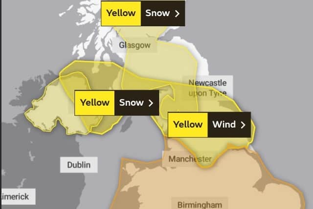
An amber weather warning is in place for part of South Yorkshire, including the southern edge of Sheffield, with a yellow warning for wind covering the rest of the city.
Rail operators have issued ‘do not travel’ warnings and drivers have been told to check before heading out, with major travel disruption expected.
Advertisement
Hide AdAdvertisement
Hide AdSchools in parts of the country have closed, with a rare red weather warning in some areas.

Storm Eunice comes less than 48 hours after Storm Dudley caused significant disruption, bringing down numerous trees in Sheffield.
Keep updating our live blog for the latest updates on the impact of Storm Eunice.
Storm Eunice Sheffield: Live updates, including travel disruption, with amber warning in place
Key Events
- Rail operators issue do not travel warnings
- Drivers told check before you travel
- Gusts of up to 59mph forecast in Sheffield
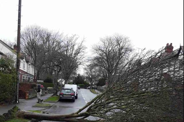
Tree comes down on Archer Road
High speed winds have brought down a tree on Archer Road.
Sheffield Council’s Streets Ahead team has confirmed a team is working to remove the tree and clear the area.
The incident does not appear to have had an impact on traffic in the area.
Storm Eunice: Yellow weather warning for ice in place for Sheffield, with risk of injuries
Just as Sheffield braces itself for the onslaught caused by Storm Eunice today, the region has been issued another yellow warning - this time for ice.
The Met Office said the weather warning for Yorkshire and Humber is valid from 6pm on Friday until 9am on Saturday, February 19, with the highest temperature between those times forecast to be 3C.
Forecasters warned that there will be icy patches on some untreated roads, pavements and cycle paths that are likely to cause injuries.
The forecast said: “Brisk northwesterly winds will continue to bring increasingly wintry showers across this area overnight on Friday and at first on Saturday.
“Some snow is likely to accumulate over around 200 m (another 10-15 cm over Scottish Mountains), but the wintry mix is more likely to bring a risk of icy roads and pavements, as surfaces left wet by showers (or hail/snow/slush) then fall below freezing.”
Most showers, however, will ease by Saturday morning.
Storm Eunice: Yorkshire Wildlife Park shut as Storm Eunice batters UK
Yorkshire Wildlife Park has been forced to close on Friday due to Storm Eunice to safeguard the safety of the animals and visitors.
On Thursday, the Met Office issued a rare red weather warning for some parts of the UK as the storm is expected to bring extremely strong winds and continued disruption for much of the country.
In Sheffield, a yellow weather warning has been issued for the city, with the Met Office forecasting gusts of up to 60mph this afternoon.
Rail passengers have also been urged not to travel to the possibility of extensive disruption caused by Storm Eunice – the second storm to hit the UK in a week after Storm Dudley.

Storm Eunice Sheffield: Hour-by-hour forecast as storm batters city - with possibility of snow
Millions of people have been advised to stay at home after a yellow wind warning was issued in Sheffield on Friday (February 18), ahead of Storm Eunice’s expected onslaught on the UK today.
The Met Office said the weather warning for the city is valid until later today, with gusts of up to 60mph forecast.
In other parts of the country, forecasters said Eunice, which could be one of the worst storms to hit the UK in three decades, has been upgraded to a rare red wind warning, the highest level.
The red warning is in place for south Wales and the northern coast of south-west England until 12pm.
People have been warned to avoid travel if possible and to remain at home when winds reach dangerously high speeds.
In Sheffield, it is forecast that there is a 90 per cent chance of heavy rain from 11am to 2pm with highs of 7C and a 70 per cent chance of heavy showers at 3pm with high winds of up to 60mph.
The Met Office said the storm will bring rain and hill snow first thing today, before clearing northeastwards to allow a brighter spell to develop during the morning.
When will Storm Eunice be at its strongest?
There may be blue skies and relatively calm conditions in parts of Sheffield this morning but that’s expected to change soon.
The latest Met Office forecast shows heavy rain between 10am and 3pm, with gusts topping 50mph from 1pm and reaching 59mph at 3pm and 4pm.
Gusts of over 40mph are expected until 10pm.
Flooding already affecting some roads
Flooding is reportedly already affecting some roads in Sheffield.
Darnall Road is among those said to be impassable.
Storm Eunice expected to cause chaos today
Storm Eunice is expected to cause chaos across the country today, with gales, heavy rain and snow forecast.
Severe weather warnings have been issued across the country, with an amber one for wind in place for part of South Yorkshire and a yellow one covering the rest of the region.
There is a chance of longer journey times or cancellations as road, rail, air and ferry services are affected by the severe weather conditions.
‘Do not travel’ warning issued by rail companies
Rail operators across the region have issued ‘do not travel’ warnings for today due to Storm Eunice.
Northern, LNER, East Midlands Railway, CrossCountry and TransPennine Express are all asking people not to use their services today.
Northern is asking passengers not to travel between 9am and 9pm today due to what it says will be ‘significant disruption’ across the network.
“Customers should expect delays and cancellations and are strongly advised not to travel on Friday 18 and to check before you travel for the rest of the weekend,” it said.
“Please check your trains as close to the time of your departure as possible and we urged you to consider whether your journey is necessary.”
It said Northern tickets dated Friday, February 18 will be valid on Northern services tomorrow, Saturday, February 19.
Drivers warned to check before they travel
National Highways is warning drivers to check before they travel today, with major disruption expected on the nation’s roads.
Jeremy Phillips, National Highways head of road safety, said: “For those who do travel, we’re encouraging drivers to check the latest weather and travel conditions before setting off on journeys and consider if their journey is necessary and can be delayed until conditions improve. If you do intend to travel, then plan your trip and take extra care, allowing more time for your journey.
“In high winds, there’s a particular risk to lorries, caravans and motorbikes so we’d advise drivers of these vehicles to slow down.
“Drivers of other vehicles should be aware of sudden gusts of wind which can affect handling and braking, and give high-sided vehicles, caravans, and motorbikes plenty of space. In the event of persistent high winds we may need to close bridges to traffic for a period, so please be alert for warnings of closures and follow signed diversion routes.”
National Highways said unladen curtain-sided vehicles are particularly vulnerable to windy conditions on high ground. Curtains on empty high-sided vehicles can act as sails when closed, and when high winds arise HGV drivers are advised to open their curtain-sided vehicles if they’re empty.
It said the northern routes most likely to be affected by Storm Eunice include the M62, A628 and A66 along with high structures and elevated areas such as Thelwall Viaduct and Shap. Snowfall between 10cm and 20cm is predicted on the A66 and possibly the A696 and A68.