Meadowhall: Historic aerial pictures of Sheffield show shopping centre and steelworks


This week Historic England launched its Aerial Photography Explorer, which for the first time allows users to search and explore an online map showing aerial photographs of Yorkshire and England over the past 100 years.
Aerial imagery provides a fascinating insight into the development and expansion of the nation’s urban centres and changes to the rural landscape.
Advertisement
Hide AdAdvertisement
Hide AdIt can also reveal striking discoveries - such as ‘crop marks’ showing hidden, archaeology beneath the surface of land.
Aerial images from Yorkshire include photographs of Roman archaeology in the Yorkshire Dales, the East Hecla steelworks and Meadowhall in Sheffield, Second World War anti-invasion measures in North Yorkshire and the impact of coastal erosion, highlighted by pictures of Fort Godwin, Kilnsea.
The Sheffield images show the East Hecla steelworks and Meadowhall in 1946 and 2007.
The photographs, taken more than 60 years apart, illustrate the dramatic change in use of this area of Sheffield.
Advertisement
Hide AdAdvertisement
Hide AdThe East Hecla steelworks was an important factory for the production of artillery shells in World War One, producing 289,200 shells.
From 1917 some of the factory’s capacity was converted to the manufacture of 60-pounder guns. Shells were also made there during the Second World War.
The East Hecla steelworks was closed in the 1980s and Meadowhall shopping centre was built on the site between 1990 and 1992.
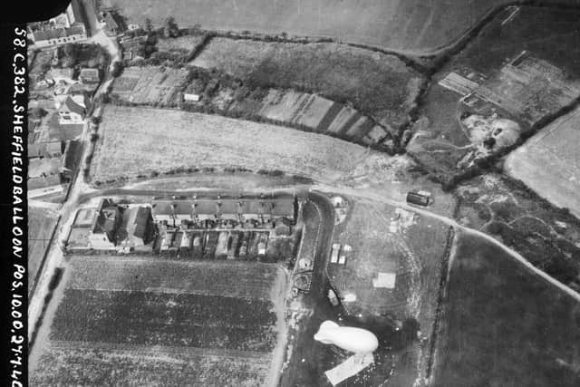
Another image taken in 1940 shows a Second World War barrage balloon between Rotherham and Sheffield.
How you can see the Historic England Aerial Photography Explorer
Advertisement
Hide AdAdvertisement
Hide AdThe balloons, an important part of airborne defences, were tethered to a ring of concrete blocks and raised and lowered from a lorry-mounted winch.
They were raised to make enemy aircraft fly higher over their intended targets and make bombing less accurate, while also forcing planes into the range of anti-aircraft guns.
Around 300,000 of the photographs in the online collection are the work of Historic England’s Aerial Investigation and Mapping team.
Established in 1967, the team takes photographs of England from the air to discover new archaeological sites, create archaeological maps and monitor the condition of historic sites across the country.

Advertisement
Hide AdAdvertisement
Hide AdThe remaining 100,000 images come from the Historic England Archive aerial photography collection, which numbers over two million images in total, and includes important historic photography, including interwar and post-war images from Aerofilms Ltd and the Royal Air Force.
By opening up these images to the public through an accessible online tool, Historic England hopes that people will use it to research their local areas, offering an insight into a century of changes and development.
Historic England chief executive Duncan Wilson said: “I am delighted that our new online tool will allow people to access easily our wonderful collection of aerial images and enjoy the historic photography that our team uses every day to unlock the mysteries of England’s past.”
Historic England aims to expand the platform, as more of the six million aerial images in its archive are digitised.
You can find the archive online at HistoricEngland.org.uk/AerialPhotos.