Sheffield weather: 24 flood warnings and 10 flood alerts, including Don and Sheaf rivers, as Storm Babet hits

and live on Freeview channel 276
A total of 24 flood warnings have been issued and 10 flood alerts are in place as Storm Babet continues to rage in Sheffield.
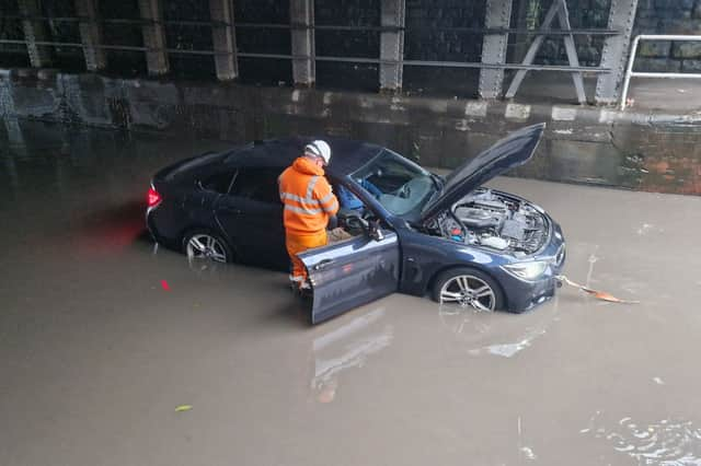

The city has been hit by heavy rain, which is forecast to continue until 9am on Saturday morning and has already caused flooding and travel disruption in many areas.
Advertisement
Hide AdAdvertisement
Hide AdThe Environment Agency has issued 224 flood warnings and 231 flood alerts across the UK, including a total of 34 in the Sheffield area, with the River Don, River Sheaf and Porter Brook among them.
Hillsborough, Endcliffe Park and Kelham Island among areas at risk of flooding
Chapeltown, Ecclesfield, Hillsbrough, Heeley and Kelham Island also among the most at-risk areas.
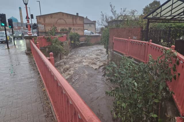
Photos and videos show the River Porter at Endcliffe Park had already burst its banks as of midday today, while the flood gates are up at Meadowhall and Millhouses Park has been closed.
Streets Ahead said at around 11.30am today that the following roads in Sheffield had all been closed due to flooding: Upwell Street, Penny Lane, Fife Street, Beaver Hill Road and Mosborough Parkway into the city.
Advertisement
Hide AdAdvertisement
Hide AdPeople in the worst affected areas are being advised to consider putting their flood plans into action. They have also been warned to avoid walking, cycling or driving through flood water.
A flood alert means flooding is possible and people should have a bag ready with vital items like insurance documents and medication in case they need to leave their home.
A flood warning means flooding is expected and people should act now to move their family and pets to safety and their vehicles to higher ground if safe to do so.
When is the rain expected to stop in Sheffield?
An amber weather warning is in place for Sheffield until 6am on Saturday, October 21.
Advertisement
Hide AdAdvertisement
Hide AdThe latest Met Office weather forecast shows heavy rain continuing until 2am on Saturday, followed by light rain until 8am that morning. The rest of Saturday looks largely dry and Sunday is forecast to be sunny, with a high of 13C
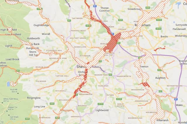
Below are all the flood warnings and flood alerts in place in the Sheffield area, including other parts of South Yorkshire and North Derbyshire, as of 4.30pm on Friday, October 20.
For more details on the latest flood warnings and alerts, and what to do if you are affected, visit: https://check-for-flooding.service.gov.uk/alerts-and-warnings.
Flood warning area: Beighton including Woodhouse Lane and Rotherham Road and Crown Works Industrial Estate.
Advertisement
Hide AdAdvertisement
Hide AdFlood warning area: Sheffield including Woodseats Close, Athol Road, Rydal Road and Abbeydale Road in Norton Hammer. Also includes Aizlewood Road, Gamston Road, Gleadless Road, Well Road, Wolseley Road, Glover Road, and Asline Road in Lowfield.
Flood warning area: Dore including Ladies Spring Drive, Ladies Spring Grove and Abbeydale Road.
River levels are rising in the River Sheaf due to persistent rainfall. Flooding in areas adjacent to the river is likely early this afternoon, 20th October 2023. Affected areas could include Broadfield Road and Markham Terrace.
Flood warning area: Ecclesfield including The Common, Linden Road, Green Lane, Station Road and Starnhill Close. Includes the cricket ground next to Ecclesfield Park and Atlas Business Park.
Advertisement
Hide AdAdvertisement
Hide AdFlood warning area: Sheffield including Attercliffe Common, Carbrook Hall Road, Dunlop Street, Carbrook Street, Weedon Street, Vulcan Road, Meadowhall Road, Meadowhall Way, Meadowhall Shopping Centre and Retail Park.
Flood warning area: Sheffield from Butterthwaite Lane, Ecclesfield to Meadowhall Interchange. Including Deep Lane, Ecclesfield Road, Grange Mill Lane, Blackburn Road, Fife Street, Meadowhall Road and Alsing Road.
Flood warning for Blackburn Brook and Charlton Brook from Chapeltown to North Ecclesfield
Flood warning area: Ecclesfield including Loicher Bridge and the works on Station Road. Chapeltown including Nether Lane, Cowley Lane, Falding Street, Station Road, Thornbrook Gardens, Cart Road, Bridge Inn Road and Newton Chambers Road.
Flooding is forecast to affect Newton Chambers Road Industrial Estate, Thornbrook Road, Station Road, Cowley Lane, Cowley Court, Falding Street, Barrel Inn Road, Lane End and the Thorncliffe Road Estate.
Flood warning for Meers Brook at Heeley
Advertisement
Hide AdAdvertisement
Hide AdRiver levels are rising rapidly on Meers Brook due to persistent rainfall. Flooding is forecast to affect areas adjacent to Carbrook this morning. Rainfall is expected throughout today, Friday 20th October 2023, and river levels are expected to remain high.
Flood warning area: Properties along Arthington Street, Bradbury Street, Molby Street, Rushdale Avenue, Canterbury Road and Meersbrook Road.
Flood warning area: Sheffield including Spital Hill and Saville Street in Burngreave. Also includes Brightside Lane and Hawke Street in Brightside.
Flood warning for River Sheaf and Porter Brook from Granville Square to Commercial Street
Flood warning area: Sheffield including Leadmill Road, Suffolk Road, Fornham Street, Turner Street, Sheaf Street, Harmer Lane, Pond Hill and Midland Railway Station.
Flood warning for River Sheaf at Broadfield Road and London Road South
Advertisement
Hide AdAdvertisement
Hide AdFlood warning area: Sheffield including Abbeydale Road, Little London Road, Broadfield Close, Broadfield Road, Saxon Road, London Road, Chippinghouse Road, Guernsey Road and Queens Road.
Flood warning area: Norton Hammer, Sheffield including Rydal Road, Langdale Road, Little London Road, Coniston Road and Arnside Road.
Flood warning area: Sheffield including the area bounded by Charlotte Road, Farm Road and St Mary's Road as far as Granville Square.
Flood warning area: Woodhouse Mill including properties on Furnace Lane and Retford Road.
Advertisement
Hide AdAdvertisement
Hide AdFlood warning area: Properties in Renishaw and Renishaw Lane End.
Flood warning area: Properties along Staveley Lane including Toadpool Farm and Slittingmill Farm.
Flood warning for Whiston Brook at Whiston, Rotherham
Flood warning area: Whiston Brook through Whiston, from Moorhouse Lane, along High Street to Meadowcroft Close.
Flood warning area: Blackburn Meadows Sewage Treatment Works and Energy Plant.
Advertisement
Hide AdAdvertisement
Hide AdFlood warning area: River Derwent at Grindleford including the B6521 to Nether Padley.
Flood warning area: River Derwent at Calver including the Caravan Parks and the riverside farms at Froggatt.
Flood warning area: Properties on Rotherside Road, Rotherham Road and Pipworth Lane.
Flood warning area: River Derwent at Bamford including the Garden Centre at Shatton and Mytham Bridge.
Advertisement
Hide AdAdvertisement
Hide AdFlood warning area: River Derwent at Hathersage for riverside farms and properties.
Flood alert area: Blackburn Brook from High Green to Meadowhall, including Charlton Brook, Ecclesfield Brook and Whitley Brook.
Flood alert for Middle River Don catchment
Flood alert area: River Don from Kelham Island in Sheffield to Hexthorpe, including Bagley Dike.Areas most at risk include The River Don from Kelham Island in Sheffield to Hexthorpe, including Bagley Dike and Carr brook and Meadowhall.
Flood alert for Porter Brook Catchment
Flood alert area: River Porter Brook and its tributaries.Areas most at risk include Parkland and sports fields are expected to flood, including Endcliffe Park.
Flood alert for River Sheaf Catchment
Flood alert area: River Sheaf and its tributaries.
Flood alert for Tributaries in North Derbyshire
Advertisement
Hide AdAdvertisement
Hide AdFlood alert area: Tributaries to the Rivers Noe, Derwent and Wye in North Derbyshire including Grinds Brook, Peakshole Water, Bradwell Brook, Stoke Brook, Bar Brook, Tideswell Brook, Warney Brook, Bentley Brook, Via Gellia and Lea Brook.
Flood alert for Upper River Don catchment
Flood alert area: River Don and its tributaries from Penistone to Kelham Island in Sheffield.
Areas most at risk include River Don and its tributaries from Penistone through Hillsborough to Kelham Island in Sheffield.
Flood alert for Lower River Rother
River levels are forecast to rise on the River Rother between Killamarsh and Rotherham, due to heavy rainfall. Flooding of low-lying land near the watercourse is likely throughout today, Friday 20th October 2023.
Advertisement
Hide AdAdvertisement
Hide AdFlood alert area: River Rother and its tributaries from Renishaw to Rotherham.
Flood alert for Upper River Rother catchment
Flood alert area: River Rother from Chesterfield to Staveley, including the Rivers Hipper, Drone and Whitting.
Areas most at risk include River Rother from Chesterfield to Staveley, including the Rivers Hipper, Drone and Whitting.
Flood alert for River Doe Lea catchment
Flood alert area: The River Doe Lea from Hardwick Hall to Staveley.
Advertisement
Hide AdAdvertisement
Hide AdAreas most at risk include The River Doe Lea from Hardwick Hall to Staveley and Buttermilk Lane.
Flood alert area: Upper River Derwent from Ladybower Reservoir to the River Wye at Rowsley.
Areas most at risk are low-lying agricultural land and roads including Bamford, Leadmill, Curbar, Grindleford, and Rowsley.
Comment Guidelines
National World encourages reader discussion on our stories. User feedback, insights and back-and-forth exchanges add a rich layer of context to reporting. Please review our Community Guidelines before commenting.