Active travel neighbourhoods: maps of all the road closures and changes in Sheffield

and live on Freeview channel 276
An active neighbourhood is where changes are made to streets with the aim of creating a safer, cleaner and quieter environment for local residents and businesses to encourage more walking, cycling and spending time outdoors.
Six month trials are currently in action in Nether Edge and Crookes so below we take a look at all the affected streets.


Advertisement
Hide AdAdvertisement
Hide AdCouncillor Douglas Johnson, who until recently was the executive member of transport, said some of these have already been implemented and others will come later.
The council said after the six months there will be a review and decisions made on which elements will stay and which will be removed or changed.
Feedback on the scheme can be given to the council by emailing [email protected] or calling 0808 196 5105.
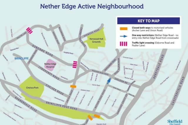
Nether Edge
Archer Lane, Osbourne Road, Nether Edge Road and Union Road are all affected by the plans in this leafy suburb sandwiched between two of the busiest roads in Sheffield – Ecclesall and Abbeydale.
Advertisement
Hide AdAdvertisement
Hide AdThe council is blocking vehicles on parts of Archer Lane and Union Road, banning waiting at any time on parts of Archer Lane and Osbourne Road and implementing a one way street on part of Nether Edge Road.
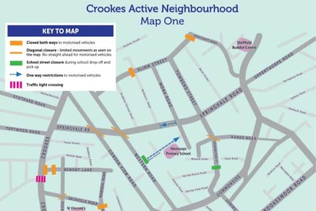
Crookes
More than 20 roads are affected by the new rules in Crookes. These are as follows:
A ban on waiting at any time on parts of: Camm Street, Cobden Place, Cobden View Road, Greenhow Street, Hands Road, Heavygate Avenue, Highton Street, Leamington Street, Matlock Road, Melbourn Road, Mona Avenue, Pickmere Road, Romsdal Road, Sackville Road, Slinn Street, Springvale Road, Townend Street, Warwick Terrace and Western Road.
Permit holders only bay on parts of Crookesmoor Road.
School streets ban on unauthorised vehicles from Monday to Friday, 8.15am to 9.15am and 2.45pm to 3.45pm at: Westways Primary School, Hands Road, Mona Avenue, Warwick Street and Warwick Terrace.
Advertisement
Hide AdAdvertisement
Hide AdBan on driving on parts of: Cobden View Road, Fir Street, Hands Road, Highton Street, Matlock Road, Matlock Road, Newent Lane, Pickmere Road, Slinn Street and Western Road.
One way streets on parts of: Greenhow Street, Heavygate Avenue, Mona Avenue and Springvale Road.