Five walks around Sheffield with good pubs at the end


There are two things that Sheffield has in abundance; scenic strolls and cosy pubs.
Merge the pair together and you’ve got a match made in heaven, with a tasty ale acting as the perfect reward for a brisk walk.
Advertisement
Hide AdAdvertisement
Hide AdDust off the hiking boots and try your hand at these Steel City walks with warm and inviting taverns at their ends.
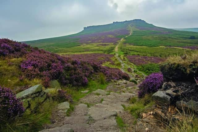
Higger Tor and Carl Wark Iron Age Fort
This route starts and finishes at The Fox House Inn in Longshaw to the southwest of the city.
From the Fox House Inn’s car park follow a path north and then northeast and amble alongside the rugged Burbage Rocks.
View of Carl Wark (Photo: JP/contributed)
Once you reach the distinctive Upper Burbage Bridge turn southwest and hike up the slopes of Higger Tor an ancient gritstone tor. From here head south towards the Iron age hillfort of Carl Wark.
Advertisement
Hide AdAdvertisement
Hide AdOnce you’ve enjoyed the views on offer descend further south towards the Fox House Inn. When you reach the inviting pub enjoy a well-earned ale and a spot of lunch or dinner.
Distance: 4 to 5 miles Time: 2 to 3 hours
Full walk description: trekkingbritain.com
Kelham Island stroll
Study Sheffield’s industrial past with this walk through the heart of Kelham Island.
Starting at Kelham Island Museum head east along the River Don's Upper Don Walk, until you reach the Lady’s Bridge. Traverse the crossing and turn left onto Nursery Street
Carry on past the site of Sheffield’s original train station, along Mowbray Street and then Neepsend Lane, before crossing the River Don for a second time over Ball Street Bridge.
Advertisement
Hide AdAdvertisement
Hide AdOnce over make a beeline for either the Fat Cat on Alma Street, or the Kelham Island Tavern on Russell Street for a drink of your choice.
Distance: 1.5 to 2 miles Time: 1-1.5 hours
Meersbrook Park walk
Circulate the pick of south Sheffield’s parks at your own leisurely pace, occasionally stopping to admire the pleasant views of the city.
Start at Meersbrook Hall, make a brief detour to the park’s walled garden before returning to the hall and strolling clockwise around the rest of the park.
Finish at Bishop’s House a timber structured building and one of the city's oldest buildings, before leaving the park and making the short trip to the Cross Scythes pub on Derbyshire Lane.
Advertisement
Hide AdAdvertisement
Hide AdThe Thornbridge Brewery owned watering hole hosts a pleasing selection of ales and snacks.
Distance: 1 mile Time: 30-45 minutes
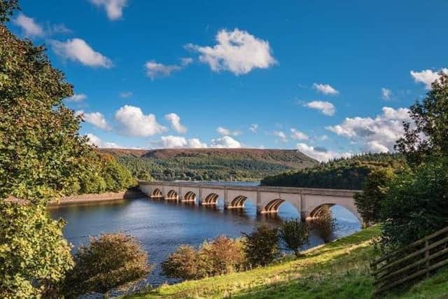
Ladybower Reservoir circuit
This walk starts and finishes at the charming Ladybower Inn.
From the pub follow a path which runs alongside Snake Pass for roughly a kilometre until you reach a bridge.
Bamford Edge can be seen from the banks of Ladybower Reservoir (Photo: JP)
Advertisement
Hide AdAdvertisement
Hide AdCross the bridge and turn right joining a path which circulates the northern finger of the Ladybower Reservoir.
Follow the path around the scenic reservoir before returning along the A57 to the Ladybower Inn for a spot of lunch.
Distance: 5 miles Time: 2 to 3 hours
Damflask Reservoir hike
Start at the east end of the Damflask reservoir and head along the south bank of the charming body of water.
Stride the length of the reservoir until you reach School Lane, turn right and cross the bridge before turning right onto Lamb Hill. Follow Lamb Hill for roughly half a kilometre before taking a path to the right along the north side of the reservoir.
Finish by joining Loxley Road and nipping along the road for a drink at the fantastic The Nag’s Head
Distance: 4 miles Time: 1.5 to 2 hours