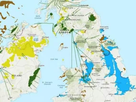
When Doncaster was beneath a huge lake: How our town looked in last Ice Age 22,000 years ago


The online map shows how cities were affected by the last glacial cycle when a half mile-thick sheet of ice covered Britain and has been unveiled by researchers at Sheffield University.
Doncaster was beneath a huge lake which covered huge parts of Northern England and the Midlands as far south as Cambridge and Milton Keynes.
Advertisement
Hide AdAdvertisement
Hide AdThe map at www.briticemap.org lets users type in a postcode to see nearby landforms such as glacial debris which records the margin of the ice sheet.
Dr Jeremy Ely, of the university’s geography department, said: “The landform information tells us about how the last British-Irish ice sheet behaved. We can see how it dammed rivers, creating large glacial lakes which covered Manchester, Doncaster and Peterborough.
“Corridors of fast flowing ice, flowed toward the east over Edinburgh and toward the west over Glasgow. Ice also covered Ireland, flowing through the Irish Sea, where it coalesced with Welsh ice, causing it to flow southward to the Isles of Scilly.”
There have been at least five documented major ice ages during the 4.6 billion years since the Earth formed.
Advertisement
Hide AdAdvertisement
Hide AdThe last one took place in the Pleistocene Epoch which began 2.6 million years ago. The ice age peaked 22,000 years ago and lasted until about 11,700 years ago.
The landforms featured in the map were left behind when a vast ice sheet covered the UK during the last ice age, carving its way through the country and leaving geographical scars that are still present today.
During the last ice age, temperatures dropped so far that snow and ice in northern regions was stopped from melting during the summer months, covering much of Scotland, Wales, the midlands and northern England in perpetual ice.
Average temperatures were 5°C (8°F) colder than they are today, allowing a one-kilometre-thick sheet of ice to cover much of the country.
Advertisement
Hide AdAdvertisement
Hide AdIce connected Britain with Scandinavia, allowing a host of large wildlife to roam free between the UK and mainland Europe.
During this period Britain would have seen the likes of woolly mammoths, giant deer and wolves roaming its icy planes.