
Sheffield Green Belt: Vital decision next week on controversial housing plan
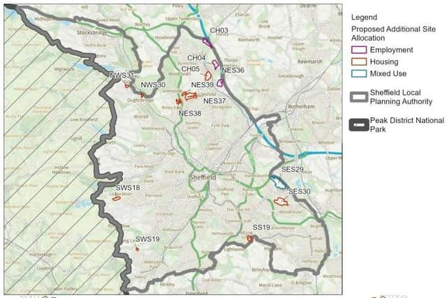
The controversial plan to identify parts of the city Green Belt where more than 3,500 homes could be built goes before Sheffield City Council next week.
An extraordinary meeting of the full council next Wednesday (May 14) will debate the proposal. It has been drawn up in response to government planning inspectors, who told the council to consider including Green Belt sites for housing in a crucial strategy document.

The inspectors are examining a draft version of the council’s Sheffield Local Plan. Once adopted, it will have legal status and will determine what types of development will be allowed in all parts of the city until 2039.
Without a Local Plan in force, the council finds it harder to justify rejecting planning applications and decisions are more easily overturned on appeal.
The council was told by the inspectors that it needs to identify sites where 3,539 more homes could be built, which would be an increase from 34,680 to 38,012.
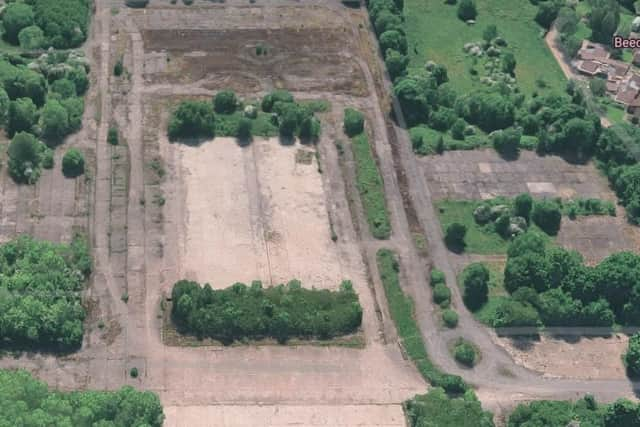
A report to Wednesday’s meeting says: “The inspectors consider that exceptional circumstances could exist to justify the release of Green Belt land for development beyond the site already proposed for allocation in the Green Belt at the former Norton Aerodrome site.
Affordable
“They note that there are some areas of land that perform relatively less well against the purposes of Green Belt and that releasing further land for development on the Green Belt would bring benefits such as helping to provide a wider mix of housing, including family homes and affordable housing.”
The inspectors also want the council to identify an additional 52.8 hectares of the city as employment land, where business developments would be allowed.
The news has been greeted with a public outcry and protest meetings. A meeting last week of the key council strategy and resources committee was also split on the proposal but it was voted through.
If the proposal is approved on Wednesday, it will then go out to public consultation for six weeks before it is considered again by the inspectors, who will hold public hearings in the autumn. Objectors can apply to present evidence and/or appear to speak.
Another round of public consultation would take place in early 2026 before the inspectors issue their final report. Finally, the council would meet to decide whether to adopt the revised Sheffield Plan, now expected to be in force by July 2026.
Lists of sites
Shortlist of housing sites:
- Land to the south of The Wheel (S35 8RY) and land between Creswick Avenue and Yew Lane (S35 8QN) – 609 homes.
- Land to the west of Grenoside Grange, Fox Hill Road (S35 8QS) and Holme Lane Farm, Halifax Road, Grenoside (S35 8PB) – 188.
- Land at Wheel Lane and Middleton Lane (S35 8PU) – 148.
- Land to the east of Chapeltown Road, Chapeltown (S35 9ZX) – 549.
- Land at Forge Lane, Oughtibridge (S35 0GG) – 69.
- Land between Storth Lane and School Lane – 103.
- Land between Bramley Lane and Beaver Hill Road, Handsworth – 868.
- Land to the south of White Lane, Gleadless Townend (S12 3HS) – 304.
- Land between Lodge Moor Road and Redmires Conduit – 258.
- Land to the north of Parkers Lane, Dore – 82.
- Handsworth Hall Farm has been proposed for seven homes plus 20 hectares of employment land.
Sites that were considered and rejected are:
-
Land to the north of Woodhouse Lane, S20 1AF;
-
Land to the west of Moor Valley, S20 5BB;
-
Land to the east of Eckington Way and south of A57, S20 1XE;
-
Land at Brightholmlee Lane, S35 0DD;
-
Land to the north of Woodhouse Lane, S20 1AF;
-
Land to the east of Long Lane and north of Hanson Road, S6 6RF;
-
Land at Stour Lane, S6 4BN;
-
Land to the west of Moss Way, S20 5AS.
Employment land sites:
- Land to the south of the M1 junction 35, S35 1QP, 16.37 hectares;
- Land bordered by M1, Thorncliffe Road, Warren Lane, and White Lane, S35 2YA, 18.06 hectares;
- Hesley Wood, north of Cowley Hill, S35 2YH, 15.61 hectares.