2.5 magnitude earthquake recorded hitting the Peak District near Buxton
and live on Freeview channel 276
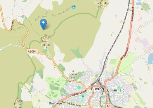
On Tuesday, January 2, at 5.30pm, an earthquake measuring 2.5 magnitude was recorded by the British Geological Survey. The earthquake was at a depth of 3km. It measured 2.5ML, or Richter Local Magnitude, and the epicentre was 2.5km north west of Buxton.
Micheal Hilton from Buxton Weather said: “I make that location 2km north west of Buxton Town Centre, near the A5004 Long Hill Road - under Combs Moss, just east of the Goyt Valley.”
Advertisement
Hide AdAdvertisement
Hide AdThe body which monitors seismic activity across the UK said there have been no reports lodged with them of this event being felt by members of the public. However several people on social media felt something.

One resident on Corbar Road said she felt it and her house shook briefly. Another said they felt it, but did not hear anything and thought they had imagined it.
A King Sterndale resident said they very much felt it and wondered what was happening. One person said their cutlery drainer made a bang in the kitchen but that was all.
The British Geological Surery notes there have been 39 earthquakes in and around the British Isles in the last 60 days and the earthquake in Buxton was the fourth biggest. The strongest was 3.9 magnitude in the Norwegian Sea at the end of November.
Advertisement
Hide AdAdvertisement
Hide AdA spokesperson for the BGS added: “Although distant from the nearest plate boundary, the Mid-Atlantic Ridge, earthquakes in the UK occur as crustal stresses within the tectonic plates are relieved by movement occurring on pre-existing fault planes.”