Coronavirus map shows the one area of Sheffield that is now almost Covid-19 free

and live on Freeview channel 276
An interactive map showing the number of confirmed positive cases in each area, based on Government data, reveals there were fewer than three cases in Crookes in the seven days to 25 November –the latest date for which reliable data is available.
The exact number of positive cases there is not known because data is not given for areas with three or fewer cases to protect individuals' identities.
Advertisement
Hide AdAdvertisement
Hide AdFive other areas of the city – the Devonshire Quarter, Cathedral and Kelham, Springvale and Steel Bank, Herdings and Gleadless Valley, and Fulwood and Lodge Moor – recorded ten or fewer new cases in the week ending 25 November.
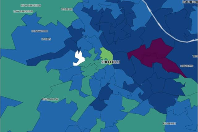

The latest available data shows there were 177 cases per 100,000 people in Sheffield in the seven days to 26 November. The average area in England had 130.
The number of positive tests during this period fell by 473 to 1,037.
Sheffield will be placed back under Tier 3 restrictions from Wednesday (2 December) until at least 16 December, when the Government will review the progress made in slowing the spread of Covid-19 in each area.
Advertisement
Hide AdAdvertisement
Hide AdOn Tuesday, NHS England confirmed a further three people who tested positive for coronavirus have died in Sheffield, bringing the total number of coronavirus-related deaths in the city’s hospitals to 484.
The total number of confirmed reported deaths in hospitals in England stood at 40,938 on Tuesday (1 December).